
Hike Report for Douglas Mountain
Douglas Mountain is located in Maine, United States. It has an elevation of 422 meters above sea level. It is located at the following coordinates: (43.8715, -70.6965).
This hike report was written by Douglas Twitchell, about a hike on Wednesday, July 20, 2016.
This report describes a hike on Ledges Trail
This report describes a hike on Ledges Trail
Not enough votes to display a rating
Directions to Ledges Trail
You can get to Douglas Mountain from route 107 in Sebago in a couple different ways. You can take the Convene Road to Orchard Road to Douglas Mountain Road, or you can take Douglas Hill Road to Douglas Mountain Road.
Note that what Google Maps calls "Douglas Hill Road" is actually called something else on the street sign (Dyke Mountain Road).
Note that what Google Maps calls "Douglas Hill Road" is actually called something else on the street sign (Dyke Mountain Road).
Hike Report
From the parking lot, we chose to go up the Ledges Trail. This meant walking back out from the car to the road, turning left, continuing up the road to where it dead-ends. The trail head is on the left.
The Ledges Trail is appropriately named, as there are a few places where you are hiking over rock ledge. Nothing that my almost-four-year-old son couldn't handle. Although on the way back down I did insist that he hold my hand over the rock face; he has a tendency to slip if he's standing on pine needles which are on top of rock ledge!
There were wild blueberry bushes everywhere, and in mid-July when we went, the berries were ripe and delicious. We had to stop several times along the way just to pick more berries.
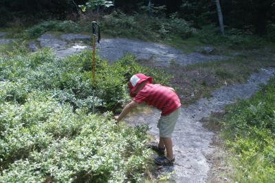
Picking blueberries!
There isn't much for views at the summit, but fortunately the stone tower gets you above the trees so you can see. From Douglas Mountain you can see Pleasant Mountain to the west, Sebago Lake to the East, and many other mountains, including Kearsarge North (Intervale, NH) and Streaked Mountain (South Paris, ME).
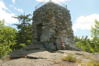
The stone tower
My son enjoyed climbing the tower so much that we had to do it twice.
The Ledges Trail is appropriately named, as there are a few places where you are hiking over rock ledge. Nothing that my almost-four-year-old son couldn't handle. Although on the way back down I did insist that he hold my hand over the rock face; he has a tendency to slip if he's standing on pine needles which are on top of rock ledge!
There were wild blueberry bushes everywhere, and in mid-July when we went, the berries were ripe and delicious. We had to stop several times along the way just to pick more berries.
Picking blueberries!
There isn't much for views at the summit, but fortunately the stone tower gets you above the trees so you can see. From Douglas Mountain you can see Pleasant Mountain to the west, Sebago Lake to the East, and many other mountains, including Kearsarge North (Intervale, NH) and Streaked Mountain (South Paris, ME).
The stone tower
My son enjoyed climbing the tower so much that we had to do it twice.
Difficulty
Easy hike - my 3 year old had no trouble whatsoever with this trail
Statistics
The trail was very short; it probably took us under half an hour to get to the summit. Eagle Scout Trail is much longer, but we didn't take that one this time. Elevation gain was just under 500 feet.
Images
Images on this page are the property of Douglas Twitchell, and may not be used without permission of the owner.

