
Hike Report for Mount Redington
Mount Redington is located in Maine, United States. It has an elevation of 1217 meters above sea level. It is located at the following coordinates: (45.025, -70.3887).
This hike report was written by Douglas Twitchell, about a hike on Wednesday, October 1, 2008.
Not enough votes to display a rating
Directions to Trailhead
Head North up route 27 from Kingfield toward Stratton. Once you pass the main entrance for Sugarloaf ski area (believe me, you won't miss that!) be watching on your left for a dirt road, called either the Caribou Valley Road or Caribou Pond Road (some maps label it one way, some the other!).
Turn onto the Caribou Valley Road - you probably won't see the sign until AFTER you've turned, so if you have doubts if you found the right road, turn onto it, and you'll see the sign.
What you do next depends on what sort of vehicle you're driving. I went with my friend Ben, who has a pickup truck, and enjoys taking it on wild rides. So we drove pretty much the full length of the CVR (about 6.5 miles), Somewhere around 5 miles in on this road, the road forks; you'll want to take the LEFT fork (which is not at all intuitive - the left fork seems to be taking you further from the mountain rather than closer).
At 6.5 miles you'll see another fork. This time the left branch is a VERY dilapidated bridge. The right branch is the trail head.
For those who don't enjoy wild rides, or don't have a vehicle designed for absurdly ill-maintained roads, you'll probably want to park just before the metal bridge, but this adds at least 2.5 miles (one way) onto your hike.
Coordinates of the Trail head:
N 45 00 34.5,
W 70 21 22.8
Hike Report
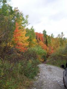
Redington was on my to-do list because it is (according to the AMC) a 4000-footer. Hiking this one leaves me just four more to go. I wanted to do this one in the fall because I wasn't convinced I'd see many nice views, so I thought we ought to at least get some nice fall foliage!
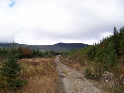
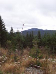
This is a hike that is quite interesting in a couple different ways. First, it's a rare mountain (here in Maine) that, when you start hiking, you're so far away from the mountain that you can see the peak in the distance. I'll post a picture of that.
Second, when you are hiking Redington, you are in the middle of a bowl formed by Sugarloaf, Spaulding, Redington, The Crockers, and Mount Abraham (Abram). Within this bowl, there isn't a hint of "civilization" beyond that one (horribly maintained) road that goes down the middle of the bowl. The result is, you are in a very natural setting. You won't hear many sounds from the outside world (which can make an eerie sort of silence, if you're not used to it, but is really very nice and peaceful). In addition, you're more likely to see interesting wildlife.
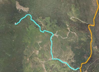
Most of the trail is actually a logging road, with a variety of forks, so I would recommend taking a GPS and plotting the coordinates of all the forks before you go. I was able to get these coordinates by viewing the region in Google Earth. I'll include the coordinates, along with instructions on what to do at each fork.
Trail Head: (take the right-hand branch)
N 45 00 34.5,
W 70 21 22.8
First Fork: (turn right here)
N 45 00 46.0
W 70 22 12.8
Second Fork: (turn left here)
N 45 01 17.2
W 70 22 11.7
Third Fork: (take rightmost of 3 branches)
N 45 01 20.6
W 70 22 29.1
* Clearing (see starred note for instructions here)
N 45 01 47.7
W 70 23 01.1
Summit
N 45 01 29.6
W 70 23 19.5
* The clearing (which you can clearly see on Google Earth) is actually not part of the trail. The trail heads off through the woods about 300 or 400 feet before you reach the clearing. It's marked with a large cairn, so you should spot it. However, I would recommend hiking past the trail junction to this clearing - from this clearing you see not only the Crockers, but also you can see East Kennebego and Snow Mountain in the distance. The views are nicer here than they are at the summit. Once you've hit the clearing, turn around and hike back about the length of a football field, and you'll find your trail to the summit.
[hr]
Ben and I enjoyed the solitude and quiet of the region, though I must confess, we were a bit disconcerted to find fresh bear tracks in the mud on the trail. The hike was fairly easy - a gradual but steady elevation gain over the course of a couple miles.
It was a fairly damp and cloudy day (the weather forecast for the day turned out to be not quite right!) so when we hit the final leg of the journey through the woods on an ill-maintained trail, we got soaked as we pushed through all the tree branches laden with moisture!
Near the summit, we came to a fork in the trail (sorry - I didn't get coordinates for that fork!) , and Ben said, "I wonder where that goes" (pointing to the left-hand fork). Ever flippant, I said, "Down," and didn't give it another thought. I shouldn't have been quite so flippant, but I'll get to that in a minute.
The summit currently has a clearing (though I wouldn't count on it being maintained as a cleared area!) and you can see the Crockers, and if you walk down the clearing a ways, you can see Sugarloaf as well. Certainly not the nicest views I've seen this summer, but the hike was interesting in other ways, so I can't complain too much. :)
Remember that fork in the trail, where I said the left-hand fork goes "Down"? Well, it turns out that on the way down the mountain, that left-hand fork (which is now the right-hand fork) is the more obvious of the two branches, so without paying attention to what we were doing, Ben and I took the wrong trail. We hiked about a quarter of a mile out of our way before we realized we were on a different trail. Then we backtracked to where we'd gone wrong.
We never did see that bear who left his paw print on our trail (for which I'm grateful) but we did see deer, and birds, and chipmunks, and a small, black, cat-like animal which moved too fast for me to get a good view of. It seems unlikely that it would be a domesticated cat so far from civilization, but I haven't been able to figure out what it was.
Finally we reached the truck, and had another wild and bumpy road back to civilization.
This is a hike that is quite interesting in a couple different ways. First, it's a rare mountain (here in Maine) that, when you start hiking, you're so far away from the mountain that you can see the peak in the distance. I'll post a picture of that.
Second, when you are hiking Redington, you are in the middle of a bowl formed by Sugarloaf, Spaulding, Redington, The Crockers, and Mount Abraham (Abram). Within this bowl, there isn't a hint of "civilization" beyond that one (horribly maintained) road that goes down the middle of the bowl. The result is, you are in a very natural setting. You won't hear many sounds from the outside world (which can make an eerie sort of silence, if you're not used to it, but is really very nice and peaceful). In addition, you're more likely to see interesting wildlife.
Most of the trail is actually a logging road, with a variety of forks, so I would recommend taking a GPS and plotting the coordinates of all the forks before you go. I was able to get these coordinates by viewing the region in Google Earth. I'll include the coordinates, along with instructions on what to do at each fork.
Trail Head: (take the right-hand branch)
N 45 00 34.5,
W 70 21 22.8
First Fork: (turn right here)
N 45 00 46.0
W 70 22 12.8
Second Fork: (turn left here)
N 45 01 17.2
W 70 22 11.7
Third Fork: (take rightmost of 3 branches)
N 45 01 20.6
W 70 22 29.1
* Clearing (see starred note for instructions here)
N 45 01 47.7
W 70 23 01.1
Summit
N 45 01 29.6
W 70 23 19.5
* The clearing (which you can clearly see on Google Earth) is actually not part of the trail. The trail heads off through the woods about 300 or 400 feet before you reach the clearing. It's marked with a large cairn, so you should spot it. However, I would recommend hiking past the trail junction to this clearing - from this clearing you see not only the Crockers, but also you can see East Kennebego and Snow Mountain in the distance. The views are nicer here than they are at the summit. Once you've hit the clearing, turn around and hike back about the length of a football field, and you'll find your trail to the summit.
[hr]
Ben and I enjoyed the solitude and quiet of the region, though I must confess, we were a bit disconcerted to find fresh bear tracks in the mud on the trail. The hike was fairly easy - a gradual but steady elevation gain over the course of a couple miles.
It was a fairly damp and cloudy day (the weather forecast for the day turned out to be not quite right!) so when we hit the final leg of the journey through the woods on an ill-maintained trail, we got soaked as we pushed through all the tree branches laden with moisture!
Near the summit, we came to a fork in the trail (sorry - I didn't get coordinates for that fork!) , and Ben said, "I wonder where that goes" (pointing to the left-hand fork). Ever flippant, I said, "Down," and didn't give it another thought. I shouldn't have been quite so flippant, but I'll get to that in a minute.
The summit currently has a clearing (though I wouldn't count on it being maintained as a cleared area!) and you can see the Crockers, and if you walk down the clearing a ways, you can see Sugarloaf as well. Certainly not the nicest views I've seen this summer, but the hike was interesting in other ways, so I can't complain too much. :)
Remember that fork in the trail, where I said the left-hand fork goes "Down"? Well, it turns out that on the way down the mountain, that left-hand fork (which is now the right-hand fork) is the more obvious of the two branches, so without paying attention to what we were doing, Ben and I took the wrong trail. We hiked about a quarter of a mile out of our way before we realized we were on a different trail. Then we backtracked to where we'd gone wrong.
We never did see that bear who left his paw print on our trail (for which I'm grateful) but we did see deer, and birds, and chipmunks, and a small, black, cat-like animal which moved too fast for me to get a good view of. It seems unlikely that it would be a domesticated cat so far from civilization, but I haven't been able to figure out what it was.
Finally we reached the truck, and had another wild and bumpy road back to civilization.
Difficulty
If you're going to do Redington, I would recommend taking either a friend who has done it before, or a GPS, or both. There are a lot of forks in the road, and making the wrong turn will send you to nowhere!
The hike itself was quite easy; you're on old logging roads almost the whole time, and the elevation gain comes quite gradually. The worst part of this hike is the last 4 tenths of a mile, which are over a trail which is horribly overgrown. We spent an hour on the first 2.5 miles, and 25 minutes on the last 4 tenths of a mile.
The hike itself was quite easy; you're on old logging roads almost the whole time, and the elevation gain comes quite gradually. The worst part of this hike is the last 4 tenths of a mile, which are over a trail which is horribly overgrown. We spent an hour on the first 2.5 miles, and 25 minutes on the last 4 tenths of a mile.
Statistics
If you drive all the way to the coordinates listed above, your total hike is just about 6 miles (round trip), and your elevation gain from trail head to summit is about 1200 feet, which is one of the lowest elevation gains I've seen for a 4000 footer.
It took us about an hour and a half to get up to the summit.
It took us about an hour and a half to get up to the summit.
Images
Images on this page are the property of Douglas Twitchell, and may not be used without permission of the owner.

