
Hike Report for Mount Chocorua
Mount Chocorua is located in New Hampshire, United States. It has an elevation of 1060 meters above sea level. It is located at the following coordinates: (43.9542, -71.2734).
This hike report was written by Douglas Twitchell, about a hike on Tuesday, August 19, 2008.
This report describes a hike on Champney Falls Trail
This report describes a hike on Champney Falls Trail
Directions to Champney Falls Trail
This is an easy trail to find. It's right off the Kancamagus Highway, and is very well marked. If you're coming from the Conway direction, it will be on your left, not too long after you pass the "Lower Falls" area on the right.
Just watch for the "Champney Falls" sign, and pull into that parking lot. As of 2008 you'll need a $3.00 day use fee. The trail head is at the back of the parking lot.
Just watch for the "Champney Falls" sign, and pull into that parking lot. As of 2008 you'll need a $3.00 day use fee. The trail head is at the back of the parking lot.
Hike Report
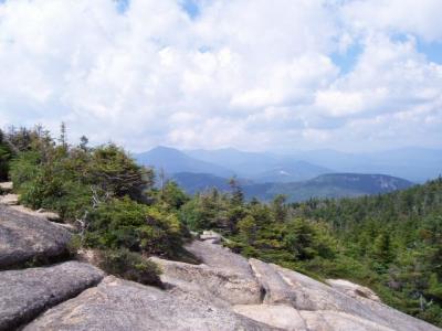
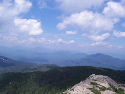
Let me begin by saying: "Wow." What extraordinary views you have from the summit of this mountain! Having done this hike once, I would do it again in a heartbeat.
My brother Jonathan and my sister-in-law Melody and I did this hike together. We had heard that the trail was quite popular, so we wanted to get an early start and beat the crowds (and the threat of thunderstorms later in the day - there was no way we wanted to be on the bare summit of Chocorua during a thunderstorm!)
We actually hit the trail at 9:00, and the first part of it is a nice leisurely stroll through the woods. There are a couple places where there are forks in the trail, but everything is VERY clearly marked, so you won't have any trouble staying on the Champney Falls Trail. The trail starts rising along a ridge, with the stream at the bottom of the ridge, so you're getting further and further from the stream bed. Then, all at once, you crest over the ridge and go back down to the stream level. Don't get discouraged by this little setback; remind yourself that it'll be worth it when you get to Champney Falls!
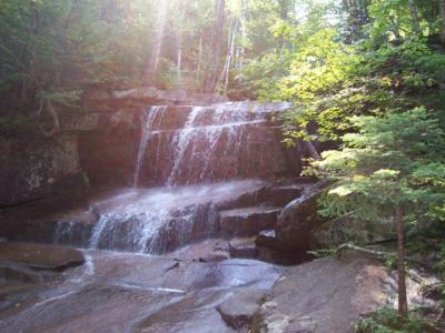
It took us less than an hour to reach the falls. There is a loop trail (clearly marked) to get to the falls. You veer to the left at the fork, and that takes you right up the side of the falls. Very pretty. And probably not more than a few extra minutes of hiking, if that.
After visiting the falls we continued on the trail and it rejoined the main trail a few minutes later. Now we were really on our way to the summit of Chocorua, and the trail started getting a bit steeper.
As you get close to the summit, you'll know you're getting somewhat close when you hit a series of switchbacks in the trail. Also, you'll start seeing some more forks in the trail, to head to the "sisters" - slightly lower peaks which are accessible off the Champney Falls trail. We didn't take any of those side jaunts. Just keep watching the signs at every junction and you won't go wrong.
The Champney Falls trail connects with the Piper Trail near the summit.
At one point, as you're hiking through the woods, you'll come to a place where you can all of a sudden see the summit through a break in the trees. You'll recognize it as the summit because 1. It is bare rock. 2. There are two "summits" with a bit of a chasm between them.
When you see that, you probably aren't more than half an hour from the summit.
Melody wasn't feeling all that well, but she was a good sport, and kept pushing forward instead of asking to go home, which I was very glad for when I realized how close we were to the summit. Jonathan and Melody made it as far as the first of the two rock peaks, then sat on the rocks while I pushed on to the main summit.
The last little bit of the hike you'll be clambering over boulders, and you should pay close attention to the yellow blazes, because if you don't, you may end up taking a much harder route than you need to.
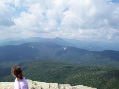
When you reach the first peak, you get some really wonderful views - in a way, J & M didn't miss too much, because the real summit (about 5 minutes more hiking) just gives you a few more views, but the best views are all visible from the first peak.
I spent a few minutes at the summit, and there was a very nice, very friendly pair of young people sitting at the summit, who I visited with while snapping pictures. They even volunteered to take my picture at the summit.
Then I turned around and headed back. We had talked earlier about maybe taking side trails to visit the three sisters, but I knew we wouldn't be doing that, with Melody not feeling well - I'll save those for the next time someone says to me, "Let's hike Chocorua!"
On the way down we skipped the loop to the falls and just went straight on by. In the last hour of our hike we saw a LOT of families hiking up. I think most of them were just going to the falls.
A great day, and a hike well worth doing. But be sure to pick a good clear day. Not just because of the safety of hiking on a bare mountain summit in bad weather, but also because the views on a clear day will knock your socks off.
My brother Jonathan and my sister-in-law Melody and I did this hike together. We had heard that the trail was quite popular, so we wanted to get an early start and beat the crowds (and the threat of thunderstorms later in the day - there was no way we wanted to be on the bare summit of Chocorua during a thunderstorm!)
We actually hit the trail at 9:00, and the first part of it is a nice leisurely stroll through the woods. There are a couple places where there are forks in the trail, but everything is VERY clearly marked, so you won't have any trouble staying on the Champney Falls Trail. The trail starts rising along a ridge, with the stream at the bottom of the ridge, so you're getting further and further from the stream bed. Then, all at once, you crest over the ridge and go back down to the stream level. Don't get discouraged by this little setback; remind yourself that it'll be worth it when you get to Champney Falls!
It took us less than an hour to reach the falls. There is a loop trail (clearly marked) to get to the falls. You veer to the left at the fork, and that takes you right up the side of the falls. Very pretty. And probably not more than a few extra minutes of hiking, if that.
After visiting the falls we continued on the trail and it rejoined the main trail a few minutes later. Now we were really on our way to the summit of Chocorua, and the trail started getting a bit steeper.
As you get close to the summit, you'll know you're getting somewhat close when you hit a series of switchbacks in the trail. Also, you'll start seeing some more forks in the trail, to head to the "sisters" - slightly lower peaks which are accessible off the Champney Falls trail. We didn't take any of those side jaunts. Just keep watching the signs at every junction and you won't go wrong.
The Champney Falls trail connects with the Piper Trail near the summit.
At one point, as you're hiking through the woods, you'll come to a place where you can all of a sudden see the summit through a break in the trees. You'll recognize it as the summit because 1. It is bare rock. 2. There are two "summits" with a bit of a chasm between them.
When you see that, you probably aren't more than half an hour from the summit.
Melody wasn't feeling all that well, but she was a good sport, and kept pushing forward instead of asking to go home, which I was very glad for when I realized how close we were to the summit. Jonathan and Melody made it as far as the first of the two rock peaks, then sat on the rocks while I pushed on to the main summit.
The last little bit of the hike you'll be clambering over boulders, and you should pay close attention to the yellow blazes, because if you don't, you may end up taking a much harder route than you need to.
When you reach the first peak, you get some really wonderful views - in a way, J & M didn't miss too much, because the real summit (about 5 minutes more hiking) just gives you a few more views, but the best views are all visible from the first peak.
I spent a few minutes at the summit, and there was a very nice, very friendly pair of young people sitting at the summit, who I visited with while snapping pictures. They even volunteered to take my picture at the summit.
Then I turned around and headed back. We had talked earlier about maybe taking side trails to visit the three sisters, but I knew we wouldn't be doing that, with Melody not feeling well - I'll save those for the next time someone says to me, "Let's hike Chocorua!"
On the way down we skipped the loop to the falls and just went straight on by. In the last hour of our hike we saw a LOT of families hiking up. I think most of them were just going to the falls.
A great day, and a hike well worth doing. But be sure to pick a good clear day. Not just because of the safety of hiking on a bare mountain summit in bad weather, but also because the views on a clear day will knock your socks off.
Difficulty
Hiking Chocorua by way of the Champney Falls Trail is not terribly difficult, though it is longer than most of the hikes I've done this summer. I haven't done any other trails on Chocorua, but I believe Champney Falls is probably easiest, since it is the most gradual incline, Near the beginning it seems like just a casual stroll through the woods. It does get a bit steeper later on in the hike, but never terribly difficult.
The last little bit is the most challenging; once you get out of the woods and on the bare rock summit, you have to do some clambering over boulders to reach the actual summit.
The last little bit is the most challenging; once you get out of the woods and on the bare rock summit, you have to do some clambering over boulders to reach the actual summit.
Statistics
It took us just a little over six hours to do this hike. About 3.5 hours up, and 2.5 hours down. Our total distance hiked was roughly 7.6 miles round trip, and our elevation gain was 2,200 feet.
Images
Images on this page are the property of Douglas Twitchell, and may not be used without permission of the owner.

