
Hike Report for Blueberry Mountain
Blueberry Mountain is located in Maine, United States. It has an elevation of 902 meters above sea level. It is located at the following coordinates: (44.7676, -70.4798).
This hike report was written by Douglas Twitchell, about a hike on Saturday, July 21, 2007.
Not enough votes to display a rating
Directions to Trailhead
To find the Blueberry Mountain, first locate on your map the intersection of routes 156 and 142 in Weld, Maine. When you arrive at this intersection, head toward Phillips on 142. You will follow this road for about 4.3 miles. You'll see a transfer station on your right, and just a little ways beyond that, on the left you will see a sign that says "Blueberry Mountain Bible Camp". The trail head is right at the Bible Camp, so you will turn in at this sign.
The camp road is about 2 miles long, and you'll find yourself at a lodge type building, with space for parking right there by the lodge. Park there, and continue walking up the road, and you will see that it heads up through the woods into a soccer field. Cross through the soccer field, and you'll be on the trail.
The camp road is about 2 miles long, and you'll find yourself at a lodge type building, with space for parking right there by the lodge. Park there, and continue walking up the road, and you will see that it heads up through the woods into a soccer field. Cross through the soccer field, and you'll be on the trail.
Hike Report
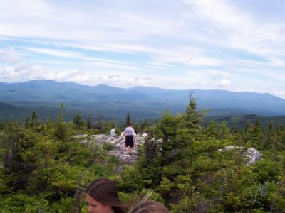
Last week I was the Bible teacher at Blueberry Mountain Bible Camp. As part of the camp activities, we had one morning that we hiked Blueberry Mountain. I was happy about this, because, although Blueberry isn't on my list of "must climb" mountains (see my profile for that list!), I'm always happy to hike a mountain I haven't hiked before.
So we started out at a few minutes past 9:00 AM with about 15 young teens, and several of the camp staff. When you hike Blueberry, you'll find that the beginning part of the hike is the hardest part. Not too long into your hiking you'll hit a section that starts uphill and just keeps on going. It's nowhere near as hard as Avery Peak, which has a similar steep section which goes on forever, but it still was a challenge for several of the teens and adults. For myself, I was quite content to stay at the back of the group, and take a more relaxed pace, because this was only my second hike of the summer, and I wasn't interested in trying to keep pace with the more energetic and athletic of the campers and staff!
After awhile you get a little relief - the trail levels off, and with the exception of one or two short steep sections, the rest of the hike is much easier.
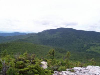
Most of the way up the mountain you are in the woods, and can't see any nice views, but when you get to the top, you can see 360 degree vistas, including most of the Weld area mountains, plus (in the distance) Sugarloaf, and - on a clear day - Mount Washington.
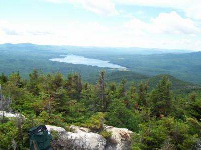
And, best of all, you can see a beautiful view of Webb Lake (part of the Mount Blue State Park).
We arrived at the peak somewhere around 10:30 AM.
At the top of the mountain we spent some time enjoying the views, and then I did a short Bible lesson from Psalm 29, which talks about the glory of God in all of creation. The Psalm says that in His temple everything cries out: "Glory!"
Finally, we turned around and headed back to the camp. The return hike was easy, although because it had been raining recently some sections of the trail were muddy, and several of us (including me!) took a tumble here and there.
So we started out at a few minutes past 9:00 AM with about 15 young teens, and several of the camp staff. When you hike Blueberry, you'll find that the beginning part of the hike is the hardest part. Not too long into your hiking you'll hit a section that starts uphill and just keeps on going. It's nowhere near as hard as Avery Peak, which has a similar steep section which goes on forever, but it still was a challenge for several of the teens and adults. For myself, I was quite content to stay at the back of the group, and take a more relaxed pace, because this was only my second hike of the summer, and I wasn't interested in trying to keep pace with the more energetic and athletic of the campers and staff!
After awhile you get a little relief - the trail levels off, and with the exception of one or two short steep sections, the rest of the hike is much easier.
Most of the way up the mountain you are in the woods, and can't see any nice views, but when you get to the top, you can see 360 degree vistas, including most of the Weld area mountains, plus (in the distance) Sugarloaf, and - on a clear day - Mount Washington.
And, best of all, you can see a beautiful view of Webb Lake (part of the Mount Blue State Park).
We arrived at the peak somewhere around 10:30 AM.
At the top of the mountain we spent some time enjoying the views, and then I did a short Bible lesson from Psalm 29, which talks about the glory of God in all of creation. The Psalm says that in His temple everything cries out: "Glory!"
Finally, we turned around and headed back to the camp. The return hike was easy, although because it had been raining recently some sections of the trail were muddy, and several of us (including me!) took a tumble here and there.
Difficulty
This hike has a section near the beginning that, while it isn't particularly steep does continue upward for quite a good length. If you aren't in shape, or if this is your first hike of the summer, you may find this section challenging. But take your time, take it at a pace that's comfortable for you, and you'll be okay. Once you get past this lengthy uphill section, it starts to level out some, and the hike gets much easier, with alternating uphill and flat sections.
My brother has done this hike with several of his children, including some of the young ones, so this can be done as a family hike.
My brother has done this hike with several of his children, including some of the young ones, so this can be done as a family hike.
Statistics
When you hike Blueberry, starting from the camp, you're already part way up the mountain (you've been driving uphill for two miles just to get to the trail!) so it really isn't that long a hike.
When the teen campers do it takes about an hour and a half for everyone to get to the top. Of course, the hike back down goes more quickly.
When the teen campers do it takes about an hour and a half for everyone to get to the top. Of course, the hike back down goes more quickly.
Images
Images on this page are the property of Douglas Twitchell, and may not be used without permission of the owner.

