
Hike Report for Streaked Mountain
Streaked Mountain is located in Maine, United States. It has an elevation of 533 meters above sea level. It is located at the following coordinates: (44.25, -70.4234).
This hike report was written by Douglas Twitchell, about a hike on Thursday, April 20, 2006.
Not enough votes to display a rating
Directions to Trailhead
From South Paris, take Route 117 as though you were going to Buckfield. Follow this road for 4.5 miles, until you reach the Streaked Mountain Road (when we hiked, the street sign for this road had been knocked over!) It is the first right hand turn after the Applewood Heights Road. Follow the Streaked Mountain Road until you pass a cemetery on the left. Immediately following this cemetery there is a small field. You can park your car by the side of the road next to this field. At the opposite end of the field from the cemetery, you will see an unmarked trail leading into the woods. This is the trail to the peak of Streaked Mountain.
Hike Report
I stopped in to see my brother Arnold and said, "You're not too busy this afternoon, are you?"
"Why?" he said. (Oh so suspicious!)
"Can't you just hear Streaked Mountain calling out to you? 'Climb me! Climb me!'"
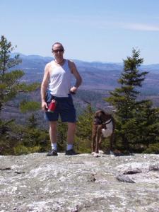
So we headed out for a hike, taking Arnold's dog Bree with us.
This was my first hike of the spring, and I hadn't done Streaked Mountain in several years. I had forgotten that this is a trail that doesn't have any "flat" parts, and it took me awhile to catch my wind.
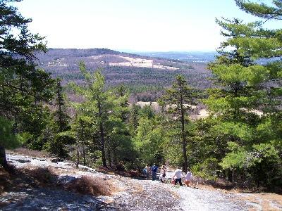
When you begin the hike, there is a sign (not quite in view from the road) that says that the trail is maintained by the students at Hebron Academy. As you hike, you will occasionally see arrows painted on the rocks telling you which way to go, but not as many or as consistent as you find on trails on the Appalachian Trail.
But that wasn't really a problem - while you're in the woods it's fairly obvious where to go, and then once you get out of the woods, you can see the towers on the peak, so there's never too much question which direction you should be going.
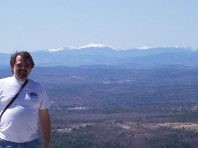
There are two or three places along the way where, if you turn around, you see very nice views of Shawnee Peak and Mount Washington. Washington was easy to spot; it was the only mountain in view that was still snow covered.
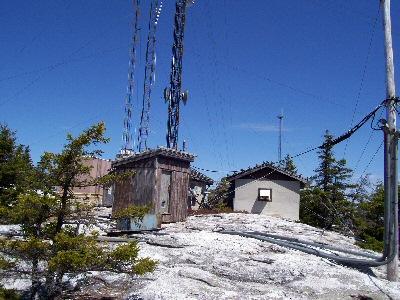
If you are looking for an area "unspoiled" by civilization, you'll be a bit disappointed by the peak; there are towers and antennas and satellite dishes and cables everywhere. But the views are quite nice, if you turn away from the man-made stuff!
On the way down Arnold and I got talking about a website we're going to be migrating next week (what do you expect when two computer geeks get together?). And we missed a trail marker somewhere, and ended up going down the wrong way.
Arnold said, "As long as Singepole is in front of us, and we're still going down, we're doing okay."
A good sentiment, and quite reasonable - Streaked Mountain Road goes directly between Singepole and Streaked, so you will eventually hit the road. What wasn't quite so reasonable was the steepness of the non-trail we took. But in the end we made it back down to the road.
As you are leaving, instead of turning around and going straight back out to 117, you could continue on straight until the Streaked Mountain Road intersects the King Hill Road, and then take that back to 117. That gives you a slightly different view of the mountain you just hiked, and is only a few miles out of your way.
"Why?" he said. (Oh so suspicious!)
"Can't you just hear Streaked Mountain calling out to you? 'Climb me! Climb me!'"
So we headed out for a hike, taking Arnold's dog Bree with us.
This was my first hike of the spring, and I hadn't done Streaked Mountain in several years. I had forgotten that this is a trail that doesn't have any "flat" parts, and it took me awhile to catch my wind.
When you begin the hike, there is a sign (not quite in view from the road) that says that the trail is maintained by the students at Hebron Academy. As you hike, you will occasionally see arrows painted on the rocks telling you which way to go, but not as many or as consistent as you find on trails on the Appalachian Trail.
But that wasn't really a problem - while you're in the woods it's fairly obvious where to go, and then once you get out of the woods, you can see the towers on the peak, so there's never too much question which direction you should be going.
There are two or three places along the way where, if you turn around, you see very nice views of Shawnee Peak and Mount Washington. Washington was easy to spot; it was the only mountain in view that was still snow covered.
If you are looking for an area "unspoiled" by civilization, you'll be a bit disappointed by the peak; there are towers and antennas and satellite dishes and cables everywhere. But the views are quite nice, if you turn away from the man-made stuff!
On the way down Arnold and I got talking about a website we're going to be migrating next week (what do you expect when two computer geeks get together?). And we missed a trail marker somewhere, and ended up going down the wrong way.
Arnold said, "As long as Singepole is in front of us, and we're still going down, we're doing okay."
A good sentiment, and quite reasonable - Streaked Mountain Road goes directly between Singepole and Streaked, so you will eventually hit the road. What wasn't quite so reasonable was the steepness of the non-trail we took. But in the end we made it back down to the road.
As you are leaving, instead of turning around and going straight back out to 117, you could continue on straight until the Streaked Mountain Road intersects the King Hill Road, and then take that back to 117. That gives you a slightly different view of the mountain you just hiked, and is only a few miles out of your way.
Difficulty
This is a short hike; the Maine Atlas and Gazetteer lists it as a 1/2 mile hike. However, it is not a relaxing 1/2 mile. Unlike many hikes, you don't have a nice, casual, shallow upgrade at the beginning. From the moment you start, you are going uphill the whole way.
I have done this hike with adults, teenagers, and I remember doing it as a child, and people in the area often do the hike as a family outing.
I have done this hike with adults, teenagers, and I remember doing it as a child, and people in the area often do the hike as a family outing.
Statistics
The trail, from the Streaked Mountain Road to the summit, is 1/2 mile. The elevation gain was approximately 800 feet. We left South Paris at about 12:30, and were back in South Paris by 2:30, so this is a hike you can do without killing an entire day.
Images
Images on this page are the property of Douglas Twitchell, and may not be used without permission of the owner.

